Grateful for a stop, we parked the van the first chance we could and then wandered the town. First impressions again of Scotland, of a major fishing port but the style and laid-back nature of Ireland. Second impression was the sheer number of Bridgestone awards that were evident on almost every building which seemed to claim to be a cafe, restaurant, take-away, bistro - did not seem to matter, it had some award or other for its cooking. One had so many awards over the years it hardly had room for them all on its wall. Not surprisingly we decided to test one out - but which one. Found our way to a bank and retired to a pub to ponder the quandary of how to choose where to eat. Not sure how we finally arrived at our choice but it was one of the few without an award, nor did it have a drinks licence. But it did have spectacular food. First the chowder for me, even the whole mussles were devoured; then a delicious piece of plaice with champ and veg & delicate sauces. Pauline opted for meat equally well served. Maybe not the best the town had to offer, but still a wonderful meal.

 Still, the next day we decided to repeat the trip go beyond. We reached the pub Tig T.P. where we paused for a pint before continuing round the headland alternately by foot & bike. The views were brilliant with small cliffs guarding the bay and its huge beach. Across the bay the cliffs would be bigger. Further round, we could see Ben Brandon shrouded in rain and more typical scenery. This was an idyllic spot.Cameback to the other pub in Ballydavid and had an interesting lunch. On the way back cycling by road, experienced the the downhill strain again; must surely be an electric-brae here with a false horizon somewheres.
We settled down for a couple of days in the site. On this second evening we explored by bike the huge beach, the remains of the Norman tower-house and Garrulus Oratory (both of which were closed - it being 10 o'clock). Planned the next day to visit the Oratory properly and maybe visit the beach for some canoeing.
When morning arrived we cycled up to the oratory and just as we were about to enter the building the rain came. Heavy, cold and wet. Aong with 3 busloads of German and other tourists, we sheltered in the building. This is reckoned as a transition building from the round, corbelled bee-hive huts to the traditional rectangular floor-planned churches. What distinguished it too was the circular window in the rear which had been carved into a group 4 or 5 substantial boulders; this feature probably dates it to 900AD rather than earlier.
 In the grounds was a standing stone with a cross and other imagery carved on it. Rather a small stone. We noticed several others though did not stop to investigate them. These stones often had Ogham incriptions; Ogham being effectively Latin but using its own alphabet; the stones date from the middle-ages and are believed to have been used as either boundary markers or as monuments as we would use headstones.
The rain had depressed our spirits so we decided to leave and head for Kerry. We actually measured it out in days so that would end up for a couple of days in Dough near Mizend Head. The camp site there had been recommended by a German tourist I met in Lettergesh. So now we had a schedule.
 Started on the Skea Head trail round the edge of Dingle back to the town. The road was narrow and often there would be little sandy bays tucked in amongst the cliffs. As we neared the most western point of Europe and the Blasket Islands, the round shrank further to a single track twisting and turning round the headlands with cliff drop on one side and sheer mountain on the other. Fortunately the traffic was quiet and we only had to reverse once - but it was a scary ride.
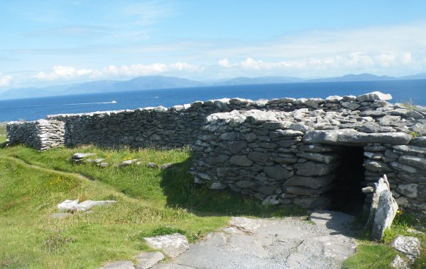 As we came round the bottom of the loop we paused at a group of Bee-Hive huts and later a stone promontory fort. The huts were scattered over the hillside and must have been similar to structures at Ceide Fields but dating seems to be way off. The fort looked like a stone version of a rath, possibly because of the abundence of local stone. This one was quite a complicated structure with guard houses built into the walls and tunnels leading underground. Erosion of the cliff had taken parts into the sea.
We should have stopped at the Prehistory Museum but we were getting a bit jaded with sight-seeing and decided to keep on motoring: past Dingle Town toward Kenmare and the Ring of Kerry.


No comments:
Post a Comment