Tuesday 12 July 2011

Ross Castle, Killarney

For our final day, the sun came out, deliciously warm.

We managed to arrive at Ross's Castle before the crowds got there, before the boatmen were even up and about. The castle is seriously impressive with several unusual features like the two points near the top for pouring oil down on attackers: one in stone on the right, and the other covered by a wooden flap near the centre.

The castle and its walls were fairly typical of a Irish chieftain's stronghold in the 15th century. It was much extended and enhanced over the centuries.

Ross Castle

The castle sits on the edge of one of the famous lakes of Killarney. The day was wonderfully clear as we cycled through the grounds. Flocks of swans preening themselves in tranquil spots. We had to give way to the stream of horse and traps filled with tourists tripping out from Killarney town to the Castle.

Killarney Lakes

After returning to the castle we head in the other direction to investigate the various monuments, structures and remains of a series of copper mine workings. It was quieter on this side with fewer tourists, no traps and hardly a boat to break the mirror still lake.

Monday 11 July 2011

Beara Peninsula

We were on a whistle-stop drive now

Approaching the end of the peninsula found a wonderful little inlet at Billeragh. The sea was incredibly clear and a wonderful shade of green. Above the cove there was a perfect camping spot, designed for a couple of campervans but by now we were on our bikes.

Billeragh and the Ring of Kerry
We headed for the end of the peninsula and Dursey Island and surprisingly found the only cable car in Ireland. It was mobbed with sight-seers and quite a queue waiting for the cable car. The car looked like an old Fiat 500 that had seen better days; the island did not appeal so we passed on the trip.
Ballaghboy Cable Car
By the time we returned to the van, the day had warmed up and the beaches near Billeragh had filled up with surfers and water boarders. It was something of a squeeze to get the van past the parked cars. We were on the road again, along the north coast of the Beara Peninsula. The most magical view of the whole trip was just around the corner: the sun lit up the beach at Ahillies and with the backdrop of the mountains, it looked spectacular (the photo doesn't even come close to how good it looked). We didn't expect to actually reach it and despite its colourful buildings, it didn't quite live up to expectations
Allihies
Continuing along the coast, the views over to the Ring of Kerry were awesome and after Allihies we hardly passed any settlement of any consequence till we approached Kenmare. But we did not pause, the weather was closing in and headed for Moll's Gap
Salmon Fishery on approach to Kenmare
The descent from Moll's Gap through Killarney National Park cannot fail to impress. We stopped at our usual view points and although nothing has changed since the last time we were here, it was just like seeing it all for the first time again.
Causeway at Killarney National Park
Be did track down the causeway that looked ready to collapse and despite a few running repairs still sagged reluctantly under the weight of traffic.

Sunday 10 July 2011

Healy's Gap

Healy's Gap: south and Cork
Left Glengariff and tootled along the rocky south side of the Beara Peninsula arriving at the start of a winding road wandering off into the distance seemingly blocked by an impassable range of sharp aretes. This was the approach to Healy's Gap


At the gap itself there was a bit of a stopping place with a monument to those who built the road. The gap marks the boundary between Cork and Kerry. Looking south to Cork there is little to see - just rock strewn moorland with a meandering road.

Healy's Gap: north and Kerry
On the other side, looking North to Kerry is the marvellous vista of a verdant plain with Macgillycuddy's Reeks in the distance. The road down this side is much steeper with some majestic view over lake and lough and country.

We had hoped to do a sort of figure-of-eight route to take us through the gap looping back to Castletownbere. It didn't quite workout that way but we did reach the town. Had an ice cream and moved on; it was getting hard to interest us by now.  We eventually stopped at Berhaven Gold Club which had hard-standing for vans. Didn't look at all promising but turned out really well

Moon rise over Bear Island
 The golf club has something to do with Padraig Harrington's family, couldn't quite figure it. Their AGM was scheduled for the night so we enjoyed a couple of beers and retired. In the morning, out in the canoe round a derlict quay from wartime and watching the local sea birds flit about the water - there was barely a breeze and the water still. It was glorious, so peaceful.


Saturday 9 July 2011

Sheepshead

View towards Carrigacat
In the morning, a few miles up the road we paused to break fast at a wonderful little cafe in Durrus. Really, a bit too sophisticated to call it a caff - like many places we had passed, euro-culture had leached into Irish life along with the blow-ins. But this had not affected the countryside or the stunning views across the lough, peppered with a variety of unexpected artefacts from history like this tower house just standing in a field.

This was an unpopulated peninsula with only occasional farmsteads to pass by. Eventually the road narrowed to such an extent, is was difficult to navigate. We found a parking place and got out the bikes.

Sheepshead Lighthouse

After 10Km or so of switch-back lanes winding through bracken, heather, gorse and limestone, even the road gave out. Fortunately at a little coffee shop to gird our loins as we set out on foot for the 3Km clamber to Sheepshead lighthouse right at the very end of the finger of land pointing into the Atlantic. The lighthouse is perched high on cliffs dropping dramatically to the coast-line remaining hidden below.


View from the light North to Beara
This was wild country and the wind coming in from the sea could knock you over. Few folk ventured anywhere near the edge of the cliffs but standing relatively safely beside the light, holding on tightly to the safety railings, the view north to the Beara Peninsula was spectacular.

Even the walk back gave some terrific views of sheer drops to the sea and the odd house or cottage nestled out of the wind; there were no trees at all out here.

Dusk at Glangariff


It was getting late now by the time we returned to the van so there was little time to savour as we headed for Bantry passing through to Glengariff. Looking down the lough gave a lot of promise for tomorrow


Friday 8 July 2011

Crookhaven

Lough-side looking toward Lackenacea
Thursday turned into a miserable day with horrendous rains after Baltimore. The only site we knew off was well along the coast past Skull. When we finally arrived at Lackenacea the sky emptied on us.

The next day the sun rose into a clear blue sky with the odd bits of fluff blowing by. And we discovered we were at the end of the world - as far as Ireland is concerned; the site was on a little isthmus - the Atlantic to one side and a crystal clear lough on the other.

After breakfast we parked at another sandy beach by Ballynaul and got the canoe out to enjoy the Atlantic. As we splashed our way about a pair of grey seals came to see what all the noise was about. The male was enormous, as big as the canoe - just as well he didn't take a dislike to us but neither came close enough. As we got back to shore a cafuffle broke out amongst some nearby tourists; a pod of about 10 common dolphins were cavorting in the lough on the other side of the road. Wow, it couldn't get much better than this.
Crookhaven: out to sea

Once we had calmed down, on our bikes to visit Crookhaven, the village further up the lough. Pauline fell in love with this place; a couple of house over looking a little harbour with a light on the opposite headland. Today the harbour was full of youngsters learning to sail. Where they all came from is beyond me, there was very little accommodation about even for summer visitors.


Sheepshead from Dunbeacon
At first we intended to carry on further west but past the campsite the road shrank to barely a track; the single track road was trying enough but this seemed too much. Instead we manoeuvred to join the coast road along the north-side of the peninsula. Our destination for the night was to be a strange little site perched precariously on the hillside near Dunbeacon. A short walk up the hill to get above the tree and shrub line and catch a glimpse of the sun poised to set behind the mountains across the way.

Thursday 7 July 2011

South West Cork

The landscape has changed now, we were finally in Cork. And so has the weather - rain has arrived, not the pelting sort, more the soft sort you don't notice till you realise you are drenched. We paused at Clonakilty marvelling at the brightly coloured store fronts and very pleasant coffee shops with yummy shop; just the ticket for a chilly, damp day.

Then a slight detour to Castletownsend sometimes fingerposted as Castletownshend. No particular reason to go there we just did. More or less a long, narrow street running downhill to the sea. At the foot, a classy hotel, a small quay of sorts and on a nearby hill, the local C of I church. If there was a shop, we missed it though a couple of ex-shops were evident.

The church hill sat well above the shoreline and gave fine views over the inlet.

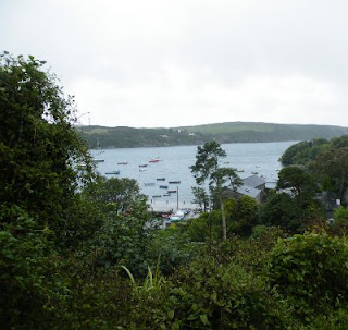
View from Castletownsend Church

The quay itself was just an small open flat area, with stores or walls on two sides of the entrance path and the rest the sea. The van was just about able to turn around to escape - reversing out was not an option.

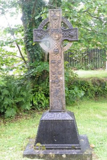
Cross in Castletownsend Church yard

Although the church was not very big and obviously not servicing a large congregation, the locals made up for lack of numbers by the quality of their breeding - at least so the gravestones suggested. Almost everyone had a title of some description either as peers or high ranking military officers, mostly naval. Grave stones were surprisingly original and not at all traditional except for a rather fine Celtic cross. Though given the blood-lines hardly a traditional cross.

It was still raining when we reached Skibbereen, a great excuse to visit the Famine museum. Despite its small size and lack of exhibits, packed a pretty good punch - well worth a visit.

On the road again to Baltimore. For some reason I expected it to be more a town rather than the tiny fishing village it turned out to be. Or rather, it had been a fishing village, now it seemed filled with holiday-homers milling around trying to learn to sale. Had a yummy lunch though below this impressive tower house.

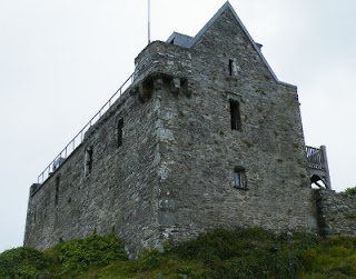
Baltimore Tower House

By now the weather was really starting to close in and visibility poor. We stuttered at Skull for some reason, a rather intense road experience with traffic everywhere going nowhere and not enough road. Phew!

Wednesday 6 July 2011

Inchydowney

We could not find anywhere to camp around Kinsale so decided to wild camp above the beach at Inchdowney. We arrived there just as the sun was going down with a spectacular sunset. Popped in for a beer or too in the hotel at the top of the hill.

Inchdowney Beach


In the morning, the local surfing school got their boards out and a crowd of youngsters descended to the beach to enjoy the waves. Pauline even had a go on her water-board; not sure whether that counts as surfing - porbably not.

Tuesday 5 July 2011

Kinsale

Kinsale has a tempestuous history and the twin forts of Charles and James guarding the entrance to the harbour emphasise this. Nowadays it is a popular up-market holiday retreat. The secluded bay offering plenty of opportunities for water-sports.

Overlooking Kinsale

I suspect the town lost its status as a major port long ago to neighbouring towns and became a preferred destination of housing developers and second-home owners. The two forts are worth visiting. James Fort on its own island is the smaller of the two and mostly derelict now; quite difficult to find as well.

Charles Fort

Charles Fort on the other hand is enormous. We arrived too late to gain admission but just walking around the fortifications gave us an inkling of the scale of the structure. The walls in the picture dwarf Pauline. This bank runs down from the entrance to the shoreline; sheer walls dominate the waterside. Despite their size, neither were ever tested in earnest.

Monday 4 July 2011

Cobh and Cork Harbour

As we approached Cork, we took a diversion through Cobh or Queenstown as it was known in the days of the Titanic (Kingstown was beside Dublin, now known as Dun Laoghaire). Cork is built on the River Lee and as Ireland's second city, the harbour was extended into the estuary centred on Cobh built on the Great Island.
Belvelly Tower House

Even in Norman times it seems, the island had significance and a rather grand Norman Tower House guards the causeway from the mainland. Although derelict, this tower is awaiting planning permission for renovation as a regular dwelling. Quite an impressive address if it works out.

Sculpture on Cobh Promenade

Cobh retains a Victorian elegance from its glory days when ships en route to America would pause here to collect Irish emigrants. There is a museum by the railway station which served as the focus for many Irish people travelling by train to join the ships docked outside. This was the last landfall made by the Titanic on its ill-fated first and only voyage.

Vacant Cobh Pub

Cobh itself is built on steep hillside dropping down to the sea. Roads twist and turn trying to compensate for the landscape and a plethora of road signs point in every direction imaginable. This makes for spectacular views from the buildings looking out over Cork Harbour but equally looking back at the Victorian grandeur - often passed its best like the temple converted to a pub and now languishing boarded up and unused. The grey granite cathedral still looks magnificent though.

Haulbowline Island Naval Base

Across the water are the wonderfully named Haulbowline Island and Spike Island. Haulbowline has been fortified since the 16th century originally by the British Army but later the Navy took over the island as a dockyard, arsenal and naval base during the Napoleonic Wars. The world's first yacht club was established here in 1720!

We never made much of Cork: our passenger window had jammed open and we searched the city for a Fiat dealer who asked us to come back in the morning. We headed out to Blarney on our first rainy day - obviously with our window stuck open. Just about had time to spot Blarney Castle before zooming in to Cork for running repairs then onto Kinsale.

Youghal

Now we were finally moving towards Cork.

Youghal (pronounced yawl) sits on the border of Waterford and Cork, yet another seaport servicing the local country upstream. It is one of the older settlements on the south coast and retains a distinctive character of a prosperous administrative and trading town.

Youghal Clock Tower

The town has a fingerposted walk guiding you through the many interesting historical buildings. On the approach to St. Mary's church is a building still retaining some of its Tudor features; this was the residence of Sir Walter Raleigh when he was mayor of the town. At that time he led quite a few military excursions throughout Ireland initiating the first of the English Plantations - as we moved further west, the number of Protestant churches increases with some locations where Church of Ireland was the only church building.

 
Rear of St. Marys

St. Marys is one of the few old churches remaining in Ireland; it grounds and graveyard terraced up the hill behind the church. One path leads to a mass grave filled during the famine with a stone coffin set at the foot of the steps; the coffin reused after carrying bodies to the grave. Inside the church displays its age with plaques, sculptures and artefacts from the many ages of the town. A rather depressing momento is the memorial to the the last duel fought in Ireland - between two junior officers stationed in the town during the 19th century, a disagreement arose during breakfast when one ignored a request to "pass the sugar"; both young men died as a consequence.

St. Marys Window
The town likely deserves more than the one day we spent exploring it but we were eager to be on our way and get to Cork.

Sunday 3 July 2011

Dunmore East

Our final day in the South East starting with a mad dash to get past Waterford to Dunmore East to catch the tall ships departing. We parked a mile or so above the little cove of Dunmore getting a spectacular view of the whole bay as the ships hoisted their sails in the open sea.

3-masters milling about in the bay

It took a while for the ships to arrive so we cycled down to the cove. On another day we might have been besotted by this quaint, Victorian village. As it was we settled behind the local lighthouse with grand views looking up the river and out to sea.


As the ships left the shelter of the river banks, their sails unfurled rounding the point in full sail; a glorious sight. It took several hours for all the big ships to pass by when we headed back up the hill to try and chase them round the coast.


Our first stop was near Kilmurrin on a promontory poking out into the Atlantic Ocean. The weather was glorious, almost too warm for watching the ships go by in the distant haze. However, it was not to be; turned out the weather forecast was bad for the next few days with strong winds blowing along the west coast. The intended route for the tall ships was round the west of Ireland, passed the Hebrides and round the top of Scotland to arrive at Edinburgh. The forecast was reckoned to be too dangerous for the crews so they turned round and headed up St. Georges Channel instead.

Saturday 2 July 2011

Waterford

Up at the scrake of dawn to get to Waterford before the crowds made it impossible. It took long enough and the crowds had already arrived but the city was very well organised with hordes of city double-deckers ferrying folk from the car parks into the city.

East Bank


Waterford, like Wexford, is a built on the banks of a river with an ancient quay running the length of the city. Waterford though is very much bigger as is the river, the bridges and the quayside. Tall ships lined both banks of the river with bunting and flags of all sorts and sizes fluttering in the breeze. It was almost a carnival atmosphere except the raucous energy of fun-rides was missing; a very civilised sort of carnival.

West bank: city side


People crammed the quays strolling up and down. Eateries, pubs and everywhere in the town was thronged with good-humoured families oogling the ships. In a little museum sort of place (where we had some yummy eats) an exhibition of photographs was on display showing the famous ships built in the city when its seaport was in its heyday. Apart from the crowds and colour there was not much difference from the riverscape of than and today.


Friday 1 July 2011

St. Margarets

By now we had discovered that the Tall Ships Race was due to arrive in Waterford over the weekend. We had spotted a sloop well in the distance sailing off Carna when we arrived but reckoned it was just a coincidence. Now we had no choice to stay just a little bit longer.. and today decided to scout Waterford to check timings, parking and the likes.

Pretty uneventful day except for the local strawberries and potatoes we collected from roadside stalls. Goodness, Wexford strawberries are soooo sweet and local Queens make gorgeous spuds, the sort of floury tatties I remember my gran making.

Sunset at St. Margarets


By the time we got back to St. Margarets, the light was fading. A quick bike ride out to the shore and catch the sun going down.

Abbaye de Saint-Savin

Abbaye de Saint-Savin from the river-side garden T he church bells announced 2 o'clock and there was already a sizeable crowd of fol...