Showing posts with label kerry. Show all posts

Tuesday, 12 July 2011

Ross Castle, Killarney

For our final day, the sun came out, deliciously warm.

We managed to arrive at Ross's Castle before the crowds got there, before the boatmen were even up and about. The castle is seriously impressive with several unusual features like the two points near the top for pouring oil down on attackers: one in stone on the right, and the other covered by a wooden flap near the centre.

The castle and its walls were fairly typical of a Irish chieftain's stronghold in the 15th century. It was much extended and enhanced over the centuries.

Ross Castle

The castle sits on the edge of one of the famous lakes of Killarney. The day was wonderfully clear as we cycled through the grounds. Flocks of swans preening themselves in tranquil spots. We had to give way to the stream of horse and traps filled with tourists tripping out from Killarney town to the Castle.

Killarney Lakes

After returning to the castle we head in the other direction to investigate the various monuments, structures and remains of a series of copper mine workings. It was quieter on this side with fewer tourists, no traps and hardly a boat to break the mirror still lake.

Monday, 11 July 2011

Beara Peninsula

We were on a whistle-stop drive now

Approaching the end of the peninsula found a wonderful little inlet at Billeragh. The sea was incredibly clear and a wonderful shade of green. Above the cove there was a perfect camping spot, designed for a couple of campervans but by now we were on our bikes.

Billeragh and the Ring of Kerry
We headed for the end of the peninsula and Dursey Island and surprisingly found the only cable car in Ireland. It was mobbed with sight-seers and quite a queue waiting for the cable car. The car looked like an old Fiat 500 that had seen better days; the island did not appeal so we passed on the trip.
Ballaghboy Cable Car
By the time we returned to the van, the day had warmed up and the beaches near Billeragh had filled up with surfers and water boarders. It was something of a squeeze to get the van past the parked cars. We were on the road again, along the north coast of the Beara Peninsula. The most magical view of the whole trip was just around the corner: the sun lit up the beach at Ahillies and with the backdrop of the mountains, it looked spectacular (the photo doesn't even come close to how good it looked). We didn't expect to actually reach it and despite its colourful buildings, it didn't quite live up to expectations
Allihies
Continuing along the coast, the views over to the Ring of Kerry were awesome and after Allihies we hardly passed any settlement of any consequence till we approached Kenmare. But we did not pause, the weather was closing in and headed for Moll's Gap
Salmon Fishery on approach to Kenmare
The descent from Moll's Gap through Killarney National Park cannot fail to impress. We stopped at our usual view points and although nothing has changed since the last time we were here, it was just like seeing it all for the first time again.
Causeway at Killarney National Park
Be did track down the causeway that looked ready to collapse and despite a few running repairs still sagged reluctantly under the weight of traffic.

Sunday, 10 July 2011

Healy's Gap

Healy's Gap: south and Cork
Left Glengariff and tootled along the rocky south side of the Beara Peninsula arriving at the start of a winding road wandering off into the distance seemingly blocked by an impassable range of sharp aretes. This was the approach to Healy's Gap


At the gap itself there was a bit of a stopping place with a monument to those who built the road. The gap marks the boundary between Cork and Kerry. Looking south to Cork there is little to see - just rock strewn moorland with a meandering road.

Healy's Gap: north and Kerry
On the other side, looking North to Kerry is the marvellous vista of a verdant plain with Macgillycuddy's Reeks in the distance. The road down this side is much steeper with some majestic view over lake and lough and country.

We had hoped to do a sort of figure-of-eight route to take us through the gap looping back to Castletownbere. It didn't quite workout that way but we did reach the town. Had an ice cream and moved on; it was getting hard to interest us by now.  We eventually stopped at Berhaven Gold Club which had hard-standing for vans. Didn't look at all promising but turned out really well

Moon rise over Bear Island
 The golf club has something to do with Padraig Harrington's family, couldn't quite figure it. Their AGM was scheduled for the night so we enjoyed a couple of beers and retired. In the morning, out in the canoe round a derlict quay from wartime and watching the local sea birds flit about the water - there was barely a breeze and the water still. It was glorious, so peaceful.


Thursday, 8 July 2010

Killarney National Park

As we headed out from Kenmare toward Killarney the road was persistently uphill. It was only when we approached the top that the significance dawned on use - we were heading deep into the mountains. Checking the map to make sure we were going the correct way and we realised we were headed for Moll's Gap.

The approach continued to have our surroundings bathed in so much mist and rain we could barely see anything. The road had improved but was still very narrow. As we got closer to the gap, the road unstraightened itself and began meandering in an easy-going sort of way. At the gap itself we were able to get some sense of the drama of the location - close to the top of the peaks, it took a while for hearing to return with the pressure.

As we began descending on the other-side we entered Killarney National Park and at several viewpoints were able to glimpse the spectacular site of the upper and lower loughs. At the bottom there was short causeway linking a pair of crags: evidently the amount of traffic it was having to support was having a negative effect and there were visible signs of it bellying out under the load.

We cam out at Killarney which seems to expanded dramatically since I was last there. We carried on though over more terrible roads through Mallow to Mitchelstown when we were able to connect with the main road to Cork - now a motorway. From there it was almost motorway all the way to Belfast. At least once we crossed the border, main trunk roads were that.

Tuesday, 6 July 2010

Ring of Kerry

When we arrived in Cahirciveen the sky decided to empty itself. On the bright side we found a really nice little cafe serving homemade carrot soup and special toasties served with wonderful coffee.

Around the town should have been very scenic but we could see little because of the rain and mist. We spent some time exploring the renovated Royal Irish Constabulary (RIC) Barracks which was an impressive Schloss-style building. The area all around here had a chequered history in all the troubles that Ireland has seen not unrelated to nearby Valentia Island where the first cable-link between Europe and America was located. In addition The Liberator, Daniel O'Connell, who almost single-handedly gained emancipation for the Catholics of Ireland, is celerbrated by a most impressive church almost exceeding the authority of Killarney Cathedral. The displays in the Barracks told us everything we needed to know.

On our way out, popped in to the Tourist Information Office and discovered we had missed a Poetry Slam the night before in a local bar. We did pick up the programme for the Bantry Literary Festival though. If I had known of either of these events beforehand may have been able to plan ahead to attend one or other. Still there was a chance we could catch something in Bantry before the festival finished.

Carried on round the west of the Ring but visibility was still poor though the hint of spectacular views was still there. After Waterville the road narrowed dramatically as we negotiated a pass through the mountains towards Caherdaniel. The mist and poor visibility made going possibly scarier than it ought to be with only our imaginings of what off the precipitous side to the road. With some relief we pitched up for the night at the camp site.

After settling in, we biked it down to O'Carroll's Cove for a beer and as it turned out in time for the Uruguay-Holland match in the World Cup. Next day P set off early in the reverse direction and discovered the wonderful beach at Derrynane by the home of The Liberator. I was called down in the van with the canoe. At the village, turned down to the beach and succeeded in arriving at a gate blocking entrance to tall vehicles. We had to give up on that so retired again to the camp site. The return trip not quite as uneventful with more traffic on the single track road.

That evening we headed down again to O'Connell's (after checking at the next-door Hotel, their extortionate menu for a very limited selection of grub). Had a homely meal and retired to the bar to watch the other semi-final, Germany vs Spain.Met a couple of Northerners who recommended a beach further on at Castle Cove. But it was not to be...

The rain started at 8:00 am. Serious rain this time, not the shower we had had in Cahirciveen. By lunchtime not only was the rain not slackening but I believe it got heavier. 3:00pm we called it day: started packing up and head for home - it was clear the weather had turned. By 4:00 we were on the road for Kenmare and Killarney; unfortunatly we picked what must be the worst road in Ireland: barely passable as a two-lane highway, only in rare parts could the van safely keep to its own side of the road, worse was the surface - full of potholes and so badly surfaced with holes, yumps, bad cambers, you name it - the Kenmare Road had it all.

Monday, 5 July 2010

Inch-Glenbigh

On the road from Dingle to Kenmare is a sand spit at Inch stretching 4 miles out into the bay. This was the strand featured in Ryan's Daughter. It is mirrored from the other side as Rossbeigh Beach near Glenbigh: this is where we were headed for the night.

The beach or Tra at Inch is spectacular. A surfing school was in progress and we were sorely tempted to stop and get the canoe out. But we reckoned we could do the same at the other side from Glenbigh so we didn't pause longer than a photo shot.

Glenbigh camp site is one of the few Carvan Club sites in Ireland and of course expensive. But you cannot avoid the style of the place; spotless does not come close. Even though facilities are not much better than Doonin, and the site is not as well presented - it still has an edge to set it apart. Though that is not necessarily appealing!

We had dinner in the Glenbigh Hotel; sadly cannot recommend it after the grub we had in Dingle. Besides the hotel claims to be the oldest in Ireland dating from 1860 or something - sounds very unlikely given the Crawfordsburn Inn dates from 17th century. After pint and pub food, set off to check out the beach at Rossbehy.

Took longer than we expected; about 4 miles in total but it was as expected a huge strand and a decent sea breaking. Sadly the parking area along the strand was governed by high gate preventing vans entering. A few parking spaces were available outside so we reckoned we would have to come down really early. On the return trip I investigated a road before the campsite to see it would be handier. It gave access to the lagoone behind the two spits at Inch and Rossbhey: the shoreline looked more interesting with small islands and inlets but certainly not as scenic. At this point we both caught the sun going down behind the mountains of Dingle.

In the morning the weather had turned definitely for the worse; the boat trip was off. So we just packed up and headed for the next port of call on our schedule - Cahersiveen.

As we drove along the fringes of the Ring of Kerry we could see absolutely nothing of the mountains: mist had drifted down to the lower slopes. Out to sea was marginaly better - we could just make out the mountains of Dingle. The views must be great though on a clear day; looking back toward Glenbigh we could just about make out the sand bar at Rossbhey reaching out to Inch.

Saturday, 3 July 2010

Dingle

The Kilrush-Tarbert ferry joined a pair of oil-fired power stations. The least salubrious section of coast we could imagine. We did not linger and set out for Tralee as fast as we could go. This felt like an extraordinarily straight road taking us through uninteresting and barren countryside - again reminiscent of Lewis. Straight through Tralee with only a thought of stopping and onward to Dingle Tow.

Grateful for a stop, we parked the van the first chance we could and then wandered the town. First impressions again of Scotland, of a major fishing port but the style and laid-back nature of Ireland. Second impression was the sheer number of Bridgestone awards that were evident on almost every building which seemed to claim to be a cafe, restaurant, take-away, bistro - did not seem to matter, it had some award or other for its cooking. One had so many awards over the years it hardly had room for them all on its wall. Not surprisingly we decided to test one out - but which one. Found our way to a bank and retired to a pub to ponder the quandary of how to choose where to eat. Not sure how we finally arrived at our choice but it was one of the few without an award, nor did it have a drinks licence. But it did have spectacular food. First the chowder for me, even the whole mussles were devoured; then a delicious piece of plaice with champ and veg & delicate sauces. Pauline opted for meat equally well served. Maybe not the best the town had to offer, but still a wonderful meal.
As the light began to fade we headed out toward Ballydavid - recommended for its bar - where the only camp site was. As we arrived a beach could be seen nearby and even more of the ruins that Dingle seemed to possess than Clare. Rain was threatening but just to get some sense of where we were, I biked off to Ballydavid and struggled back as the light had almost gone, rain had arrived and the wind was up again against me; what seemed to be a downhill ride became a struggle - and then the chain came off!

Still, the next day we decided to repeat the trip go beyond. We reached the pub Tig T.P. where we paused for a pint before continuing round the headland alternately by foot & bike. The views were brilliant with small cliffs guarding the bay and its huge beach. Across the bay the cliffs would be bigger. Further round, we could see Ben Brandon shrouded in rain and more typical scenery. This was an idyllic spot.Cameback to the other pub in Ballydavid and had an interesting lunch. On the way back cycling by road, experienced the the downhill strain again; must surely be an electric-brae here with a false horizon somewheres.

We settled down for a couple of days in the site. On this second evening we explored by bike the huge beach, the remains of the Norman tower-house and Garrulus Oratory (both of which were closed - it being 10 o'clock). Planned the next day to visit the Oratory properly and maybe visit the beach for some canoeing.

When morning arrived we cycled up to the oratory and just as we were about to enter the building the rain came. Heavy, cold and wet. Aong with 3 busloads of German and other tourists, we sheltered in the building. This is reckoned as a transition building from the round, corbelled bee-hive huts to the traditional rectangular floor-planned churches. What distinguished it too was the circular window in the rear which had been carved into a group 4 or 5 substantial boulders; this feature probably dates it to 900AD rather than earlier.

In the grounds was a standing stone with a cross and other imagery carved on it. Rather a small stone. We noticed several others though did not stop to investigate them. These stones often had Ogham incriptions; Ogham being effectively Latin but using its own alphabet; the stones date from the middle-ages and are believed to have been used as either boundary markers or as monuments as we would use headstones.

The rain had depressed our spirits so we decided to leave and head for Kerry. We actually measured it out in days so that would end up for a couple of days in Dough near Mizend Head. The camp site there had been recommended by a German tourist I met in Lettergesh. So now we had a schedule.

Started on the Skea Head trail round the edge of Dingle back to the town. The road was narrow and often there would be little sandy bays tucked in amongst the cliffs. As we neared the most western point of Europe and the Blasket Islands, the round shrank further to a single track twisting and turning round the headlands with cliff drop on one side and sheer mountain on the other. Fortunately the traffic was quiet and we only had to reverse once - but it was a scary ride.

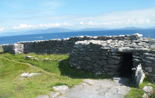
As we came round the bottom of the loop we paused at a group of Bee-Hive huts and later a stone promontory fort. The huts were scattered over the hillside and must have been similar to structures at Ceide Fields but dating seems to be way off. The fort looked like a stone version of a rath, possibly because of the abundence of local stone. This one was quite a complicated structure with guard houses built into the walls and tunnels leading underground. Erosion of the cliff had taken parts into the sea.

We should have stopped at the Prehistory Museum but we were getting a bit jaded with sight-seeing and decided to keep on motoring: past Dingle Town toward Kenmare and the Ring of Kerry.

Abbaye de Saint-Savin

Abbaye de Saint-Savin from the river-side garden T he church bells announced 2 o'clock and there was already a sizeable crowd of fol...